![]() Moshi, Tanzania
Moshi, Tanzania
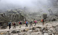
The Rongai route stands as the exclusive pathway leading towards Kilimanjaro from the northern direction, situated adjacent to the Kenyan border. Despite its growing appeal among climbers, this trail remains relatively underutilized, attracting fewer visitors compared to other routes.
Day 1
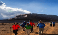
Simba Camp, located at an elevation of approximately 1997 meters (6552 feet) to 2635 meters (8645 feet), offers breathtaking panoramic views of the surrounding landscapes. Departing from Moshi via a four-to-five-hour drive through coffee plantations and villages, travelers arrive at the Kilimanjaro National Park gate where they will await their permits. During this period, visitors can observe various crew preparations, enjoy lush woodlands, and experience the wind-swept trails. A guided tour highlights the local flora and fauna, offering insights into the potential wildlife encounters. Simba Camp, situated near the first cave, provides splendid vistas of Kenya’s plains.
Day 2
Simba Camp to Second Cave Camp, covering a distance of approximately 5.8 kilometers (3.6 miles) over five to six hours, ascends to an elevation of 2635 meters (8645 feet) to 3487 meters (11,440 feet). As participants settle in for the night, they prepare for another challenging ascent. The moorland area transitions into a thinning shrub landscape, gradually cooling temperatures.
Day 3
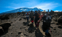
Second Cave Camp to Third Cave Camp, covering a distance of approximately 3.3 kilometers (2 miles) in three to four hours, involves ascending to an elevation of 2635 meters (8645 feet) to 3936 meters (12,913 feet). After breakfast, participants embark on a steady climb, gaining altitude by 449 meters (1468 feet). They venture into the semi-desert region, experiencing a shorter but still significant hike. Their bodies adapt during this phase, prompting them to pay close attention to their health and communicate any symptoms of altitude sickness to their guides promptly.
Day 4
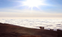
Third Cave Camp to Kibo Huts, covering a distance of approximately 6.7 kilometers (4.2 miles) in four to five hours, takes climbers to an elevation of 3936 meters (12,913 feet) to 5174 meters (16975 feet). Participants start their descent early in the morning from the third cave, passing through the semi-desert terrain. They reach the Kibo Huts, just below the Kibo Crater Wall, after a brief stop. Here, they transition onto the Marangu Route to complete the remaining ascent to the summit.
Day 5
Kibo Huts to Summit, covering a distance of approximately 4 kilometers (2.5 miles) in five to seven hours, culminates in reaching an elevation of 5174 meters (16975 feet) to 5895 meters (19,341 feet). The descent begins at 3721 meters (12,208 feet), followed by a loss of 2174 meters (7125 feet) in altitude.
Day 6
Marangu Gate to Horombo Huts, covering a distance of approximately 20 kilometers (12.5 miles) in six to seven hours, descends to an elevation of 3721 meters (12,208 feet) to 1905 meters (6250 feet). An additional loss of 1816 meters (5959 feet) in altitude completes the descent.
| Highlights |
|
|---|---|
| Includes |
|
| Not suitable for |
|
Free cancellation
Cancellation up to 24 hours prior will result in a full refund.
Reserve now & pay later
Maintain flexibility in your travel arrangements by booking your destination and paying nothing at this moment.
Valid 1 day
Please verify the schedule to determine the available start times.
Live tour guide
Please provide the original text for rewriting in a formal manner.
Maintain flexibility in your travel arrangements by booking your destination and paying nothing at this moment.
Check Availability
![]() Moshi, Tanzania
Moshi, Tanzania ![]() See on map
See on map
The primary goal of the Rongai route is to lead hikers towards Mount Kilimanjaro from the northern direction.
Despite being less utilized than some other routes, the Rongai route attracts fewer climbers compared to others.
Simba Camp is situated at an elevation ranging between approximately 1997 meters (6552 feet) and 2635 meters (8645 feet) above sea level.
During Day 2, participants ascend to an elevation of around 2635 meters (8645 feet) to 3487 meters (11,440 feet), encountering a transition from moorland to a thinning shrub landscape with cooler temperatures.
On Day 3, participants traverse through a semi-desert region while gaining altitude by 449 meters (1468 feet).
The Kibo Crater Wall marks the end of the ascent on the Rongai route, providing a clear boundary for the climber's journey up to the summit.
![]() Moshi, Tanzania
Moshi, Tanzania

![]() Moshi, Tanzania
Moshi, Tanzania
![]() Moshi, Tanzania
Moshi, Tanzania
![]() Moshi, Tanzania
Moshi, Tanzania
![]() Moshi, Tanzania
Moshi, Tanzania
![]() Moshi, Tanzania
Moshi, Tanzania
![]() Moshi, Tanzania
Moshi, Tanzania
![]() Moshi, Tanzania
Moshi, Tanzania
9.4/10
Excelent

![]() Moshi, Tanzania
Moshi, Tanzania
9.0/10
Excelent

![]() Moshi, Tanzania
Moshi, Tanzania
8.8/10
Very good

![]() Moshi, Tanzania
Moshi, Tanzania
8.8/10
Very good

![]() Moshi, Tanzania
Moshi, Tanzania
8.7/10
Very good

![]() Moshi, Tanzania
Moshi, Tanzania
8.0/10
Very good

![]() Moshi, Tanzania
Moshi, Tanzania
8.0/10
Very good

![]() Moshi, Tanzania
Moshi, Tanzania
8.0/10
Very good

![]() Moshi, Tanzania
Moshi, Tanzania

Subscribe to our newsletter and get the best offers!
By entering your email address, you agree to receive personalized offers and automated commercial communications, including promotions about our products and services, as well as those from selected partners (without sharing your data with third parties). For more details or to withdraw your consent, please refer to our Privacy Policy. You can unsubscribe at any time via the link in the email.