10/10
Excelent
![]() Refugio El Pilar, La palma, Spain
Refugio El Pilar, La palma, Spain
Embark on an exhilarating hiking expedition that commences at the El Pilar Refuge and traverses the rugged terrain bordering the southern mountain range, culminating in a breathtaking ascent to nearly 2,000 meters above sea level, ultimately reaching Los Canarios, the ultimate destination.
10/10
Excelent
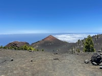
One of the most popular routes on La Palma, renowned for its stunning beauty and rich landscape, is undoubtedly the Volcanoes Route. Spanning approximately 17 kilometers, this spectacular volcanic itinerary offers breathtaking panoramas that reveal the island's recent geological history.
The Ruta de los Volcanes is the ideal means to explore the most volcanic region of the island, allowing visitors to experience landscapes that evoke a sense of sci-fi wonder, reminiscent of a hypothetical visit to Mars. Additionally, the tour provides unparalleled panoramic vistas of both sides of La Palma, sometimes even offering glimpses of neighboring islands: Tenerife, La Gomera, and El Hierro. This unique vantage point showcases the diverse terrains of the island, including lush pine forests interspersed with varying shades of volcanic terrain.
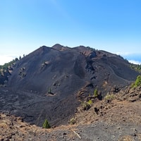
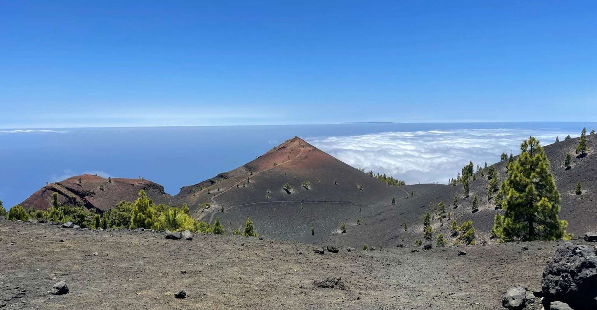
Guided tours of the Volcanoes Route provide valuable insights into the island’s volcanic history, narrated by knowledgeable guides who share fascinating tales of lava flows, ash deposits, calderas, and explosive volcanic events that intertwine with the distinctive green hues of the Canary Island pine. As you traverse the youngest volcanic areas, characterized by multiple active volcanoes forming part of the Cumbre Vieja Natural Park, your journey becomes a blend of awe-inspiring natural wonders and historical narratives.
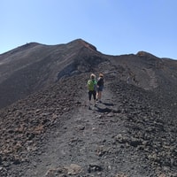
This challenging route requires participants to maintain excellent physical fitness throughout the 17-kilometer journey from the Refugio de El Pilar refuge to Los Canarios (Fuencaliente). Starting at the Refugio El Pilar, travelers follow the GR-131 trail, ascending towards the Pico Birigoyo peak. Alongside this ascent, the scenic view includes the Aridane Valley, the Caldera de Taburiente, and the Roque de Los Muchachos—high points within the island of La Palma.
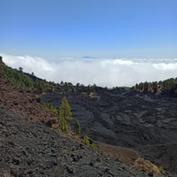
Continuing along the path, you'll encounter various municipalities, such as El Paso, Los Llanos de Aridane, and Tazacorte, as you climb higher until reaching the crater of Hoyo Negro. Here, the mesmerizing cloud formations created by the mountain's mist make for a truly unforgettable sight.
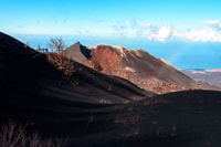
From Hoyo Negro, the descent commences, leading you to the picturesque Volcán de Martin, the last crater encountered before arriving at the concluding point of the guided tour. Characterized by an imposing reddish cone, this area offers expansive views of the surrounding landscape, particularly when the weather permits.
Finally, after descending to Los Canarios (Fuencaliente), your journey concludes with a comfortable transfer back to your starting point. Throughout the trip, you're guaranteed to capture memories that will remain etched in your mind forever.
In summary, the Volcanoes Route on La Palma offers a captivating exploration of the island's volcanic heritage, providing not just a visual feast but also an educational journey through the island's geological past.
| Highlights |
|
|---|---|
| Includes |
|
Free cancellation
Refunds will be provided upon cancellation at least 24 hours prior to the scheduled event.
Reserve now & pay later
Maintain your travel arrangements as adaptable as possible; make reservations now and incur no charges initially.
Duration 8 hours
Please verify the schedule for available start times.
Live tour guide
The languages mentioned in the text are Spanish, German, and English.
Small group available
Please provide me with the original text to be rewritten in a formal manner.
Maintain your travel arrangements as adaptable as possible; make reservations now and incur no charges initially.
10/10
(2 reviews )Check Availability
![]() Refugio El Pilar, La palma, Spain
Refugio El Pilar, La palma, Spain ![]() See on map
See on map
La Palma Airport
10.42 km
The Volcanoes Route is one of the most popular routes on La Palma, known for its stunning beauty and rich landscape. It spans approximately 17 kilometers and culminates in the breathtaking ascent to nearly 2,000 meters above sea level, ultimately reaching Los Canarios.
The Volcanoes Route begins at the El Pilar Refuge.
The entire Volcanoes Route takes around 17 kilometers to complete.
The highest point reached during the Volcanoes Route is nearly 2,000 meters above sea level, which is the summit of the volcano.
Visitors can expect to see stunning panoramas revealing the island's recent geological history. The tour provides unmatched panoramic vistas of both sides of La Palma, sometimes even offering glimpses of neighboring islands: Tenerife, La Gomera, and El Hierro.
Yes, the Volcanoes Route requires participants to maintain excellent physical fitness throughout the 17-kilometer journey from the El Pilar Refuge to Los Canarios. The ascent involves maintaining altitude gain while navigating alongside the GR-131 trail, passing through various municipalities such as El Paso, Los Llanos de Aridane, and Tazacorte.
At the conclusion of the Volcanoes Route, visitors can look forward to capturing memorable moments. After descending to Los Canarios (Fuencaliente), they are transferred back to their starting point. Throughout the trip, guests are assured to capture images that will stay etched in their minds forever.

Subscribe to our newsletter and get the best offers!
By entering your email address, you agree to receive personalized offers and automated commercial communications, including promotions about our products and services, as well as those from selected partners (without sharing your data with third parties). For more details or to withdraw your consent, please refer to our Privacy Policy. You can unsubscribe at any time via the link in the email.